Everest Cho La Pass Trek - 17 Days

An Adventure Everest Base Camp Chola Pass Trek with Gokyo Lake 17 Days Itinerary for 2026/2027
Everest Cho La Pass Trek

Everest Cho La Pass Trek adds a zest of additional adventure to the regular Everest Base Camp Hike by letting you cross one of the high passes of the Khumbu region, Chola Pass. This particular trek in the Everest region is designed for those who are looking to step up their level in the Himalayas one step at a time. The trek will allow you to cross one of the challenging passes of the region, from where you get to witness exceptional landscapes. Moreover, the pass trek also takes you to the picturesque Gokyo Valley.

facts icon

What to see & do

Specific information about Everest Cho La Pass Trek - 17 Days
duration icon
Duration17 Days
grade icon
Trip GradeStrenuous
i
altitude icon
Max Altitude5550M
start icon
Starts atKathmandu
end icon
Ends atKathmandu
travel-style icon
Travel StyleLodge to Lodge Trek
group-size icon
Group Size8
transportation icon
TransportationPrivate Vehicles and Flights
cloud-sun-rain icon
Best SeasonSpring and Autumn

Highlights of the Everest Cho La Pass Trek

  • Your adventure kicks off with a thrilling aerial flight to Lukla's cliffside runway, one of the world's most nerve-wracking airstrips, a proper adrenaline jolt that tells you immediately this trip means business.
  • Walk across suspension bridges draped in prayer flags while glacial rivers roar far below, it's noisy, beautiful, and slightly terrifying in the best way possible.
  • Namche Bazaar is different. Fresh-baked bread, Sherpa legends, and mountaineering museums packed with climbing history — this little town quietly earns its title as the soul of the Khumbu.
  • At Tengboche Monastery, juniper smoke hangs in the air, and monks chant as Ama Dablam towers behind the walls.
  • Everest Base Camp is louder than you'd expect, the icefall groans and shifts, tents glow in every color, and you're standing right where the world's boldest climbers have stood. It doesn't disappoint.
  • Sunrise from Kala Patthar or Gokyo Ri turns the sky gold over the world's highest peaks; no photo does it justice, and honestly, neither will your words when you try to explain it back home.
  • Crossing the Cho La Pass at 5,420m is genuinely hard, with ice underfoot, boulders overhead, but reaching the other side feels like something you'll brag about for years.
  • The Gokyo Lakes are almost unsettlingly calm. Turquoise water reflecting giant peaks in a valley most trekkers skip, you'll wonder why everyone rushes past this.
  • Hotel Everest View exists to make you feel smug with a warm cup in hand, a picturesque scene of Mount Everest framed in the window, the highest luxury hotel on the planet living up to every word of that title.
  • Sagarmatha National Park doesn't feel real. Rhododendron forests, musk deer at the trail's edge, the elusive snow leopard sighting, and Sherpa teahouse hospitality waiting at every stop.
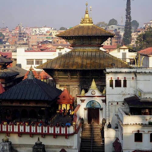
  • Before the ascent, immerse yourself in the vibrant energy of Kathmandu’s UNESCO sites. The spiritual energy of Swayambhunath and the rhythmic circling of pilgrims at Boudhanath Stupa provide the perfect cultural foundation for your journey.

Everest Cho La Pass Trekking Overview

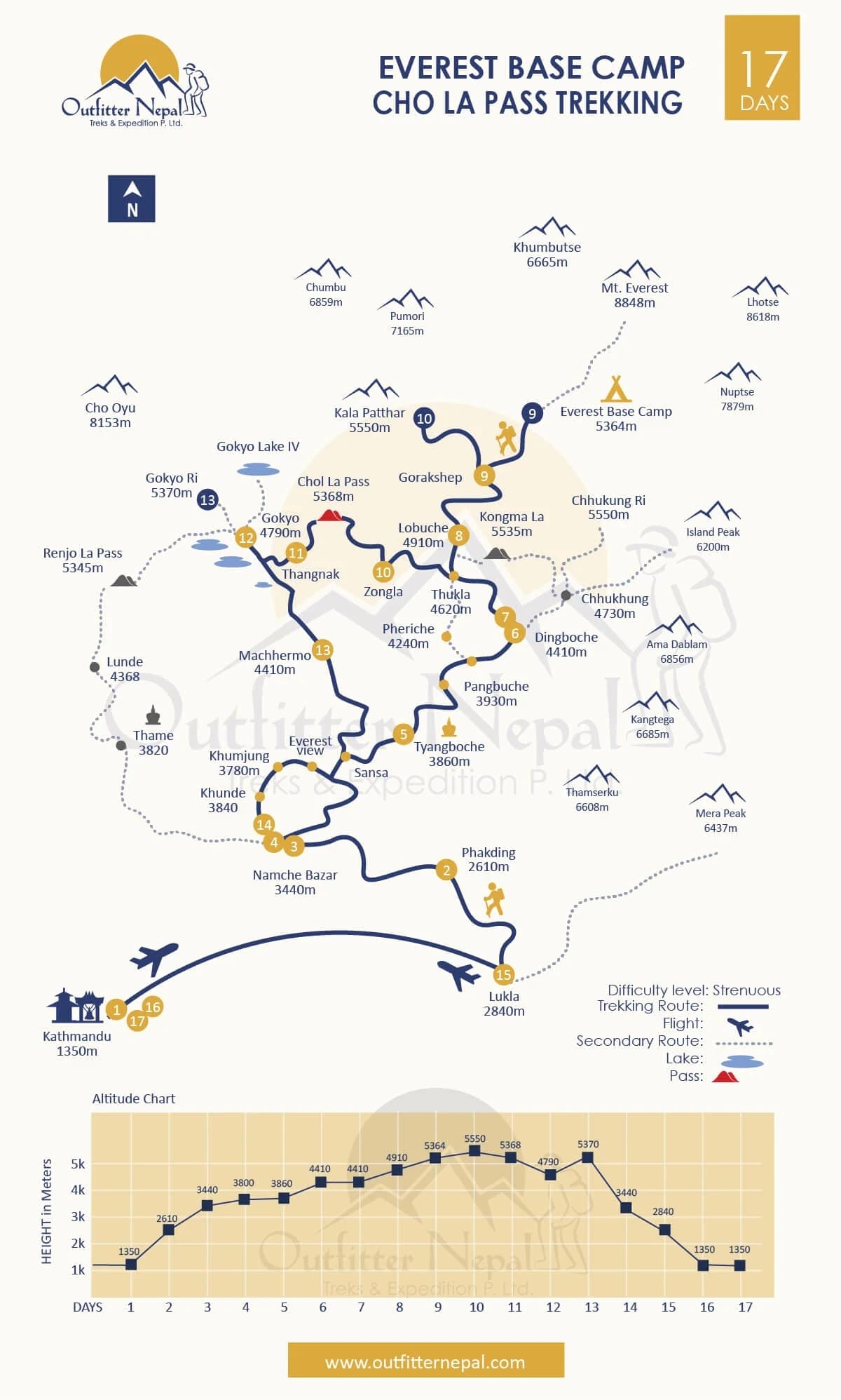
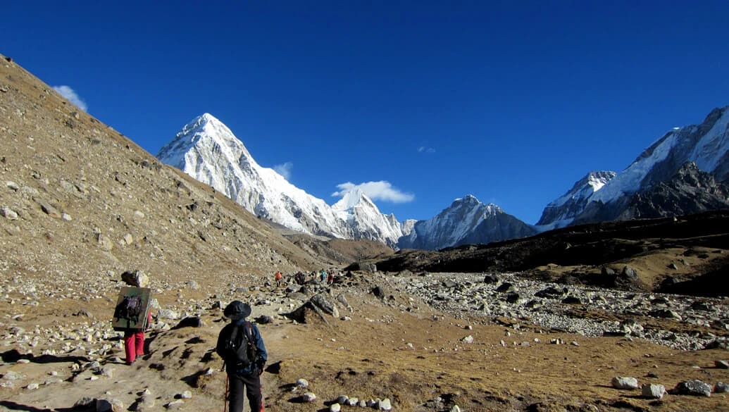
The Everest Cho La Pass Trek is the best way to explore the Khumbu region of Nepal without retracing your steps. Over 17 days, you will travel to Everest Base Camp (5,364m/17,598ft) with the Gokyo Lakes in a complete loop, so you finish somewhere different from where you started. What separates it from the standard route is that the trail drops into quieter side valleys, past the Ngozumpa Glacier, the longest in the Himalayas, and away from the crowded trails.

​The Cho La Pass (5,420m/17,782ft) is where the trek gets interesting and thrilling. The boulder chutes and icy eastern slabs require crampons or microspikes, and a level of focus most trekking trails don't ask for. We leave at 4:00 AM that day, not because it sounds adventurous, but because crossing on firm snow before the afternoon wind picks up. The descent to Thagnak is equally exciting, but you have to make it in time before the sun starts to melt the snow, making it difficult to walk on.

Similarly, the turquoise Gokyo Lakes are another major highlight of this journey. These six glacial lakes are located at altitudes ranging from 4,700 to 5,000 meters (15,400 to 16,400 feet), still and pristine, with almost no one around. Similarly, the trek is equally rewarding for photography enthusiasts, as Gokyo Ri (5,357m/17,575 ) and Kala Patthar (5,555m/18,519) are perfect vantage points for panoramic shots of the Himalayan giants. You will have scenic views of peaks such as Lhotse (8,516 m/27,940 ft), Makalu (8,485 m/27,838 ft), Cho Oyu (8,188 m/26,864 ft), and Everest (8,848.86 m/29,031.7 ft) .

What Can You Expect During the Everest Chola Pass Trek?

The Everest Cho La Pass Trek is a high-altitude journey that shifts dramatically from the humid, rhododendron-scented trails of the Dudh Koshi riverbanks to the stark, alpine region of the high Himalayas. After the scenic 35-minute Lukla flight, you’ll spend your first week acclimatizing in Sherpa hubs like Namche Bazaar and Tengboche, where the sound of morning monastery prayers provides a spiritual getaway with the views of Ama Dablam.

As you push past Dingboche, the lush forests disappear, replaced by a barren alpine desert of glacial moraines and massive snow-capped giants. The real spirit of this trek is tested when you leave the classic Everest Base Camp trail for the rugged Cho La Pass. Although arriving at the iconic Base Camp at 5,364 meters (17,598 feet) and witnessing a sunrise transform the summit of Everest into gold from the summit of Kala Patthar are experiences of a lifetime, it is the crossing of the Cho La Pass (5,420 meters/17,782 ft) that makes this route something to remember.

Look forward to a pre-dawn start, often around 3:00 or 4:00 AM, to ensure the snow on the glacier remains firm. You’ll likely need microspikes or crampons to navigate the slippery ice chutes that make Cho La more demanding than the standard EBC route. Once you conquer the pass, you’ll descend into the serene, "off-the-beaten-path" region of the Gokyo Valley. Here, the landscape transforms again into a scene of jaw-dropping beauty as you encounter a series of five turquoise glacial lakes that are sacred to both Hindus and Buddhists.

You’ll traverse the Ngozumpa Glacier, the longest glacier in the Himalayas, before reaching Gokyo Village. The trek concludes with a final climb to Gokyo Ri (5,357m), which many experienced guides consider the best viewpoint in Nepal, offering a 360-degree panorama of four of the world’s six highest peaks: Everest, Lhotse, Makalu, and Cho Oyu.

How Difficult is the Everest Cho La Pass Trek?

The Everest Cho La Pass Trek is graded as strenuous, and for good reason, it's the most technical stretch of the classic Three Passes trail. At 5,420 meters, you're running on roughly half the oxygen as compared to at sea level, which makes every step feel more demanding. But the real challenge isn't just the altitude; it's the point where trekking stops, and active scrambling on ice and snow begins.

You'll work through steep, boulder-strewn chutes and a vast glacier. We always advise hitting the trail early, since walking on the snow while it's still frozen solid makes the crossing safer. Also, it keeps you ahead of the loose rockfall that builds as the afternoon sun warms the slopes.

​Besides, keep in mind the hike won’t be easy; you need to be comfortable navigating the terrain with microspikes or full crampons. While you don't need professional mountaineering skills, traversing the Cho La glacier involves route-finding over crevassed ice and slick, angled slabs. The descent toward Thagnak is particularly taxing, featuring a 720-meter drop over unstable scree and talus slopes that can be bone-shaking after a long day.

Most trekkers find crossing from the EBC side (starting in Dzongla) more manageable because the ascent is more gradual, whereas the climb from the Gokyo side is much steeper and hits your lungs significantly harder from the first step. ​​Beyond the technical bits, the difficulty is cumulative. You’re spending nearly two weeks straight above 3,500 meters, which wears down your physical reserves through "high-altitude living".

It’s a mental game as much as a physical one. There will likely be a moment, halfway up a 400-meter scree slope at 5,000 meters, where your legs feel heavy and your body wants to quit. Nonetheless, to prepare, don't just run on a flat treadmill; spend 3-6 months hiking hilly terrain with a 5-7kg pack to simulate your actual daypack weight. That sense of accomplishment at the summit is earned only by respecting the Khumbu’s raw power and by following a disciplined acclimatization schedule in Namche and Dingboche.

Why Choose Outfitter Nepal for EBC Cho La Pass Trek?

Our expertise is tied to local heritage and years of experience on the trail. Our founder, Namaraj Gauli, spent years as a guide before establishing Outfitter Nepal with Raj Kumar Basnet in 2008. When we lead you over the technical Cho La Pass, we aren't just following a map; we’re following a strategic plan for your safety.

On this expedition, we treat acclimatization as a physiological necessity, using pulse oximeters to track your oxygen saturation as we transition into the thin air above 4,000 meters. Additionally, we don’t just sit on the rest day; our guide will lead active excursions to the Sherpa Culture Museum in Namche or the Yeti Skull Monastery in Khumjung, helping your body adapt naturally.

​This personalized, science-backed pacing is why we’ve maintained a 99% success rate over two decades of Himalayan expeditions. Additionally, beyond the trail, we adhere to strict International Porters Protection Group (IPPG) norms, ensuring our local crew has the same accidental medical insurance and quality gear that we provide for our clients. Our strict safety rules and careful trekking methods ensure every Himalayan trip in the Everest Region is safe and dependable.

Everest Cho La Pass Trek - 17 Days Itinerary Outline

  • Day 01: Arrive at Kathmandu airport (1,350m/4,429ft) and transfer to the hotel
  • Day 02: Kathmandu/Ramechhap - Lukla (2,840m/9,317ft) - Phakding (2,610m/8,563ft)/30–35 minute flight duration/ 8 km (5 miles)/3–4 hours
  • Day 03: Trek from Phakding to Namche Bazaar (3,440m/11,286ft)/10.4–11.3 km (6.4–7 miles)/6–7 hours hiking.
  • Day 04: Acclimatization at Namche Bazaar: Hike to Everest View Hotel (3,880m/12,729ft)/Distance: 3–4 km/Duration: 3–4 hours round-trip.
  • Day 05: Trek from Namche Bazaar to Tengboche (3,860m/12,664ft)/Distance: 8.6–10 km (5–6.2 miles)/5–6 hours walking.
  • Day 06: Trek from Tengboche to Dingboche (4,410m/14,468ft)/Distance: 11.8km/7.3mi (5.6–6.6 miles)/5–6 hours walking.
  • Day 07: Rest day at Dingboche for acclimatization: Hike to Nagarjun Hill (5,100m/16,732ft)/ 4 km/3–4 hours round-trip.
  • Day 08: Trek from Dingboche to Lobuche (4,910m/16,108ft)Details/7.7km/4.8mi/5–6 hours walking.
  • Day 09: Trek from Lobuche to Everest Base Camp (5,364m/17,598ft) and back to Gorakshep (5,164m/16,942ft)/15km/9.3mi/7–8 hours hiking.
  • Day 10: Trek from Gorakshep to Kala Patthar (5550m/18208ft) and Trek to Dzongla (4,830m/15,846ft)/10km/6.2mi/7–9 hours hiking.
  • Day 11: Trek from Dzongla – Cho La Pass (5,420m/17,782ft) – Thagnak (4,700m/15,420ft)/12km/7.5mi/7–9 hours (strenuous technical crossing).
  • Day 12: Trek from Thagnak to Gokyo (4,790m/15,715ft)/4 km/2.5Mi/3–4 hours walking.
  • Day 13: Trek to Gokyo Ri (5,357m/17,575ft) and back to Machhermo (4,470m/14,665ft)/11.5km/7.1mi/7–8 hours hiking.
  • Day 14: Trek from Machhermo to Namche Bazaar (3,440m/11,286ft)/10.5km/6.5mi/6–7 hours walking.
  • Day 15: Trek from Namche Bazaar to Lukla (2,840m/9,317ft)/18km/11mi/7–8 hours hiking.
  • Day 16: Fly from Lukla to Kathmandu/Ramechhap (1,350m/4,429ft) and transfer to hotel/30–35 minute flight duration.
  • Day 17: Transfer to the international airport for the final departure
Everest Chola Pass Trek Route Map

Cost Details

Good to know before trip booking

What's Included

We believe in transparent pricing, so you can have a look at our all-inclusive package, which covers the essentials of your 17-day journey:

  • Cozy Accommodations: You will stay two nights at a handpicked 3-star hotel in Kathmandu. During the trek, we provide 14 nights in traditional mountain lodges. We prioritize nice rooms, which keeps you more comfortable in the trip.
  • Meals: We provide full-board meals (breakfast, lunch, and dinner) every day of your 15-day trek. To keep your energy high, we serve hot tea or coffee three times a day and provide fresh fruit snacks every evening after dinner.
  • Flights and Private Transfers: Your package includes return domestic flights between Kathmandu and Lukla. During the busy peak season, if flights are diverted, we handle all ground transport to and from Ramechhap in private tourist vehicles. We also provide full airport pickup and drop-off services upon your arrival and departure.
  • Your Expert Support Team: You’ll be led by a government-licensed, English-speaking guide with deep knowledge of Sherpa culture and the high passes. To help with the heavy lifting, we provide one reliable porter for every two trekkers (carrying up to 12-13 kg per person). We take care of all staff salaries, meals, insurance, and equipment.
  • Safety and Health Monitoring: Your safety is our absolute priority. With that in mind, our guide will carry a comprehensive medical kit and an oximeter to check your pulse and oxygen saturation twice daily. This allows us to monitor for symptoms of altitude sickness (AMS) and ensure every level of trekker is in safe hands.
  • All Required Permits: We handle the complex paperwork for you, including the Sagarmatha National Park entry ticket, the Khumbu Pasang Lhamu Rural Municipality pass, and the Tengboche Monastery entry permit.
  • Trekking Gear and Gifts: To save you luggage weight, we provide a high-quality down jacket and a four-season sleeping bag for use during the trek (to be returned after the trek). You’ll also receive an Outfitter Nepal souvenir featuring a detailed Everest route map, a company T-shirt, and a memory cap.
  • Trek Completion Honors: Upon successfully crossing the Cho La Pass and reaching Base Camp, we provide an official Everest Cho La Pass Trek finishing certificate to commemorate your achievement. Also, you will have a farewell dinner with your trek guide and our travel planner at an authentic Nepalese restaurant.

What's not Included

While we cover the major logistics, there are a few personal expenses and third-party fees you should plan for:

  • International Travel: Your international airfare to and from Nepal and your entry visa fee ($50 USD for 30 days, obtainable at the Kathmandu airport) are not included.
  • Mandatory Travel Insurance: You must have personal travel insurance that specifically covers high-altitude trekking (up to 5600m) and emergency helicopter evacuation.
  • Dining in the City: While we provide full-board meals, you will have to pay for your own meals at the cafes and restaurants.
  • Trail Extras: Most teahouses charge a small fee for Wi-Fi, battery charging, and hot showers (outside of Namche and Lukla). These small costs are not included in the package.
  • Personal Sips and Snacks: Soft drinks, bottled mineral water, alcohol, and treats like chocolate, cakes, or desserts at the lodges are your responsibility.
  • Technical Gear Rental: For the icy sections of the Cho La Pass, microspikes and gaiters are required year-round. If you don't bring your own, they can be rented or bought at local trek shops.
  • Baggage Limits: Your Lukla flight includes 15 kg of total weight. Any excess baggage fees must be paid directly to the airline.
  • Gratitude (Tipping): Tipping your guide and porter is a longstanding tradition in the Himalayas. While it is at your discretion, it is highly appreciated by the local crew as a sign of a job well done.

Dates & Prices

Book your trip with confidence

Your Trek, Your Timeline (Customized Just for You)

You don’t have to wait for a group to fill up to start your 17-day Everest Cho La Pass adventure. Because we specialize in private, customizable trips, you can choose any start date that fits your personal schedule. Our team takes care of all the heavy lifting—from arranging your Lukla flights to organizing your mountain lodges—so you can simply focus on the climb while we manage the logistics.

Guaranteed Starts (No Minimum Group Size)

We believe in giving you peace of mind from the moment you book. Once your trek is confirmed, it is 100% guaranteed to depart. Whether you are a solo traveler or trekking with a small group of friends, we will never cancel your trip due to small participant numbers. You will receive the exact same high-quality service, professional guiding, and included features we promise to every guest, no matter the size of your group.

Stress-Free Rescheduling and Refunds

We understand that travel plans can sometimes change unexpectedly. And, if you need to cancel your trip, just let us know 20 days before your departure. On the other hand, if you find you need to postpone rather than cancel, your deposit remains valid until you decide on the next schedule. You can move your trek to a different month or even year, so you don't lose your investment.

Select a departure month

Showing Departures of May 2026
Starts: Thursday
May 14, 2026
Ends: Saturday
May 30, 2026
Price (Per Person)
US$1597
Availability
Guaranteed
Starts: Sunday
May 17, 2026
Ends: Tuesday
Jun 02, 2026
Price (Per Person)
US$1597
Availability
Guaranteed
Starts: Tuesday
May 19, 2026
Ends: Thursday
Jun 04, 2026
Price (Per Person)
US$1597
Availability
Guaranteed
Starts: Thursday
May 21, 2026
Ends: Saturday
Jun 06, 2026
Price (Per Person)
US$1597
Availability
Guaranteed
Starts: Sunday
May 24, 2026
Ends: Tuesday
Jun 09, 2026
Price (Per Person)
US$1597
Availability
Guaranteed
Starts: Tuesday
May 26, 2026
Ends: Thursday
Jun 11, 2026
Price (Per Person)
US$1597
Availability
Guaranteed
Starts: Thursday
May 28, 2026
Ends: Saturday
Jun 13, 2026
Price (Per Person)
US$1597
Availability
Guaranteed
Starts: Sunday
May 31, 2026
Ends: Tuesday
Jun 16, 2026
Price (Per Person)
US$1597
Availability
Guaranteed

Detail Itinerary

Trip day to day detail itinerary
Day01

Arrive at Kathmandu airport (1,350m/4,429ft) and transfer to the hotel

When you first step off the plane at Tribhuvan International, your adventure officially kicks off. You’ll head into the arrivals hall to sort out your visa formalities. If you want a head start, filling out the entry form online before you fly lets you scan a QR code at a touch-screen kiosk and skip the data-entry lines. It’s usually fastest to pay the visa fee in cash using crisp US dollars.

​Once you've claimed your bags and pushed through the exit doors, just look for our representative waiting in the crowd with a “OutFitter Nepal” placard. They’ll lead you to our vehicle for the drive into the city. After we get you checked into your hotel, the rest of the day is entirely yours. You can catch up on some sleep to shake off the jet lag or just take a slow, easy walk through the winding neighborhood alleys to get your bearings.

  • max-altitude iconMax. Altitude: 1350m/4429ft
  • accomodation iconAccommodation: 3 Star Hotel
  • transportation iconTransportation: Private Vehicles
Day02

Kathmandu/Ramechhap - Lukla (2,840m/9,317ft) - Phakding (2,610m/8,563ft)/30–35 minute flight duration/ 8 km (5 miles)/3–4 hours

We’re up early today for the flight that everyone talks about. Depending on when you're traveling, we'll either fly straight from Kathmandu or take the seasonal detour through Ramechhap. If it’s the latter, expect a bit of a road trip in the middle of the night to reach Manthali Airport.

​The touchdown at Tenzing-Hillary Airport in Lukla is a memory that sticks with you. The runway is short, sloped, and carved right into the mountainside. Once we’re on the ground and the adrenaline settles, we’ll grab our bags and meet up with the rest of our team. This is where you’ll get to know your Sherpa guide and the porters who will be taking care of your heavy gear throughout the journey.

​Before we officially hit the trail, we’ll stop for a hot lunch in Lukla to fuel up. We get our first local permit, the Pasang Lhamu Rural Municipality entry, just past the memorial gate as we leave town. From there, the adventure truly starts.

​The first day of walking is actually quite gentle. The trail is mostly downhill, winding through lush pine forests and small Sherpa settlements like Chheplung and Thado Koshi. You’ll hear the constant rush of the Dudh Koshi River far below as we cross our first suspension bridges draped in colorful prayer flags. Don't forget to walk clockwise around any mani stones or prayer wheels we pass; it's the local way to wish for a safe trip.

​If the sky is clear, keep an eye out for Thamserku Peak towering over the valley. After about three hours of easy pacing, what we call "bistari, bistari" (slowly, slowly), we’ll finally reach the quiet riverside lodges of Phakding. It’s a perfect introduction to teahouse life, where you can settle in, grab a cup of ginger tea, and listen to the river as you rest up for the climb ahead.

  • max-altitude iconMax. Altitude: 2610m/8563ft
  • meal iconMeals: Breakfast, Lunch and Dinner
  • elevation-gain iconElevation Gain: 1260m/4134ft
  • accomodation iconAccommodation: Mountain Lodge
  • walking-hour iconWalking Hours: 3-4 hours
  • walking-distance iconWalking Distance: 8.7km/5.4mi
  • transportation iconTransportation: Drive and Plane
Day03

Trek from Phakding to Namche Bazaar (3,440m/11,286ft)/10.4–11.3 km (6.4–7 miles)/6–7 hours hiking.

After a slow start in Phakding, you’ll head out following the turquoise Dudh Koshi River as it rushes downstream. The morning walk is actually quite pleasant, weaving through thick forests of pine and rhododendron that smell incredible in the crisp mountain air. You'll cross several suspension bridges draped in prayer flags, which might test your balance a bit if you aren't used to them, but the views of the river below are worth it.

By early afternoon, you'll roll into Benkar and then Monjo, the last stop before Sagarmatha National Park begins. There's a bit of a pause here while your guides sort through the permit scans and registrations. Not the most thrilling part of the day, but it doesn't take long. Then comes the Hillary Suspension Bridge, and that's where things get real. It sways high above the river confluence , high enough to make your stomach drop if you look down, and it's probably the most photographed spot in the whole Khumbu. There's a reason for that.

Once you’re across, the "gentle" part of the day is over. The trail turns into a long, steep zigzagging climb through the trees. It’s a tough walk that will definitely remind you of the altitude, but if the weather is stable, you’ll be rewarded about halfway up with your very first proper look at Mount Everest and Lhotse peeking over the mountain ridges.

We’ll eventually pull into Namche Bazaar, which is a sight you won't forget. It’s a colorful, horseshoe-shaped town built right into the side of a steep mountain slope. As the commercial heart of the region, Namche has a bit of everything—from bakeries and trekking gear stores to Irish pubs where you can grab a drink and swap stories with other hikers before we settle in for the night to acclimatize.

  • max-altitude iconMax. Altitude: 3440m/11286ft
  • meal iconMeals: Breakfast, Lunch and Dinner
  • elevation-gain iconElevation Gain: 830m/2723ft.
  • accomodation iconAccommodation: Mountain Lodge
  • walking-hour iconWalking Hours: 6-7 hours
  • walking-distance iconWalking Distance: 11.3km/7mi
Day04

Acclimatization at Namche Bazaar: Hike to Everest View Hotel (3,880m/12,729ft)/Distance: 3–4 km/Duration: 3–4 hours round-trip.

We’re staying put in Namche today, but don't call it a "day off." This is a vital part of the trek where we let our bodies adjust to the thinner air using the classic "climb high, sleep low" approach.

Our morning starts with a steady hike up to the Everest View Hotel at 3,880 meters. This is one of the highest hotels on Earth, offering a panoramic view of Everest, Lhotse, and Ama Dablam. There’s nothing quite like grabbing a hot coffee or tea on the terrace and just watching the clouds swirl around the majestic peaks.

If you have the energy, we can push a bit further into the twin villages of Khumjung and Kunde to get a real feel for rural mountain life. In Khumjung, you’ll find the Hillary School, established by Sir Edmund Hillary in 1961 to provide education for Sherpa children. We’ll also visit the Khumjung Monastery to see their most famous and controversial relic: an actual "Yeti scalp" kept under lock and key. Nearby in Kunde village, we can see the Kunde Hospital, which has been providing essential medical care to this remote region since 1966.

On the way back, we pass Syangboche Airport, a tiny emergency landing strip that offers a fantastic view of Namche Bazaar tucked into the mountains below. Once we’re back in town, we’ll visit the Sherpa Culture Museum. It’s a great way to spend the afternoon, as the museum is packed with climbing history and local artifacts that show exactly how the Sherpa people have lived and thrived in the shadow of Everest for generations.

  • max-altitude iconMax. Altitude: 3440m/11286ft
  • meal iconMeals: Breakfast, Lunch and Dinner
  • elevation-gain iconElevation Gain: 440m/1443ft
  • elevation-loss iconElevation Loss: 440m/1443ft
  • accomodation iconAccommodation: Mountain Lodge
  • walking-hour iconWalking Hours: 1.5-2 hours
  • walking-distance iconWalking Distance: 3.5km/2.2mi
Day05

Trek from Namche Bazaar to Tengboche (3,860m/12,664ft)/Distance: 8.6–10 km (5–6.2 miles)/5–6 hours walking.

Today’s walk is a classic Himalayan journey that feels like a tale of two very different halves. You’ll start by winding out of the busy streets of Namche Bazaar on a scenic, mostly flat trail that hugs the side of the mountain. This part of the day is all about the views; on a clear morning, you’ll have Everest, Nuptse, and the iconic Ama Dablam right in your line of sight for hours.

By midday, the terrain becomes easier as the trail drops sharply through rhododendron and pine forests toward the Dudh Koshi River. You’ll cross a suspension bridge and find yourself in Phunki Tenga, a small settlement that makes for a perfect lunch stop. Look for the water-powered prayer wheels near the river to take pictures and videos.

Eventually, the effort of the hike pays off the moment you arrive the ridge at Tengboche. The village is home to the Dawa Choling Gompa, the oldest and largest monastery in the Khumbu and the spiritual heart for the local Sherpa people. After you’ve dropped your bags at the lodge, it’s worth heading to the monastery courtyard to witness the evening prayers. There is something incredibly grounding about listening to the low hum of the monks’ chants and the occasional blow of a conch shell while the sun sets behind the massive Lhotse and Nuptse.

  • max-altitude iconMax. Altitude: 3860m/12664ft
  • meal iconMeals: Breakfast, Lunch and Dinner
  • elevation-gain iconElevation Gain: 420m/1378ft.
  • accomodation iconAccommodation: Mountain Lodge
  • walking-hour iconWalking Hours: 5-6 hours
  • walking-distance iconWalking Distance: 10km/6.2mi
Day06

Trek from Tengboche to Dingboche (4,410m/14,468ft)/Distance: 11.8km/7.3mi (5.6–6.6 miles)/5–6 hours walking.

Today’s journey starts with a gentle walk through the quiet, shaded forests of pine and rhododendron toward Deboche. It’s a peaceful stretch that leads down to a suspension bridge over the rushing Imja River. From there, it's uphill to Pangboche. The monastery is worth a stop if you have the time. It's one of the oldest in the Khumbu, and you can feel that when you're standing in it, the kind of place that clearly means something to the people who've lived around it for generations.

As we leave Pangboche behind, you’ll notice the landscape around you begin to change. The trees thin out and then disappear altogether, and suddenly you're walking through open alpine meadows. Shortly after, the trail climbs steadily past old stone walls and yak corrals that look like they've been there forever.

The stretch of trail after the small settlement of Somare has very little vegetation and is often quite exposed to the elements. We’ll follow the open valley along the shores of the Imja River, where you might notice your breathing getting a bit heavier as the air starts to feel thinner.

Finally, we’ll reach Dingboche, a unique village where stone houses are scattered across a wide valley floor between high ridges. It is often called the "Summer Valley" because of the stone walls built to protect crops from the wind. It’s definitely colder and windier than your last stop, but the 360-degree views of peaks like Lhotse, Island Peak, and Ama Dablam are some of the best you'll experience on the whole trip. We'll settle into a local tea house for the night to rest and recharge.

  • max-altitude iconMax. Altitude: 4410m/14468ft
  • meal iconMeals: Breakfast, Lunch and Dinner
  • elevation-gain iconElevation Gain: 550m/1804ft.
  • accomodation iconAccommodation: Mountain Lodge
  • walking-hour iconWalking Hours: 5-6 hours
  • walking-distance iconWalking Distance: 11.8km/7.3mi
Day07

Rest day at Dingboche for acclimatization: Hike to Nagarjun Hill (5,100m/16,732ft)/ 4 km/3–4 hours round-trip.

Today you’ll climb up Nangkartshang Hill, a steep trail that will test your legs. The path gets harder as the air becomes thinner, so trekkers need to move slowly and pace themselves.

This acclimatization hike follows the smart rule of high-altitude trekking: climb high during the day, then sleep low at night.

Cholatse and Island Peak also come into perfect view, while the whole Imja Valley stretches out below like a frozen river. After taking in these stunning mountain sights, you'll walk back to your cozy lodge in Dingboche for a big lunch and an afternoon break.

  • max-altitude iconMax. Altitude: 4410m/14468ft
  • meal iconMeals: Breakfast, Lunch and Dinner
  • elevation-gain iconElevation Gain: 675m/2214ft
  • elevation-loss iconElevation Loss: 675m/2214ft
  • accomodation iconAccommodation: Mountain Lodge
  • walking-hour iconWalking Hours: 2-3 hours
  • walking-distance iconWalking Distance: 4Km/2.8mi
Day08

Trek from Dingboche to Lobuche (4,910m/16,108ft)Details/7.7km/4.8mi/5–6 hours walking.

After leaving the wide meadows of Dingboche, the trail starts to angle upward. Today is a steady, slow-paced trek, about 5 to 6 hours in total, where the focus is more on maintaining a steady pace rather than rushing the distance.

The first big challenge of the morning is the ascent toward Thukla. As we move higher, the vegetation thins out, leaving us with a rugged, high-alpine environment. The climb up to Thukla Pass (sometimes called Dughla Pass) is the toughest section of the day. It’s steep, and the altitude definitely makes its presence known, but the view from the top makes the effort worth it.

At the top of the pass, we’ll stop at a memorial spot on the trail. You’ll see rows of stone cairns and fluttering prayer flags. These are dedicated to the brave climbers and Sherpas who lost their lives on Everest. It’s a reflective place that serves as a reminder of the power of these mountains before we continue our own journey.

From the pass, the trail levels out slightly as we navigate across the lateral moraine of the Khumbu Glacier. The ground here is a mix of massive boulders and loose scree, creating a grey, moon-like landscape that feels like another planet. Keep your camera ready for close-ups of Pumori, known as “Everest’s Daughter,” and Khumbutse.

Finally, we’ll reach the small settlement of Lobuche, tucked right under the shadow of the Lobuche summit. There are only a few tea houses here, nestled along the banks of the Lobuche River. Once we drop our packs and settle in, make sure to catch the golden hour in the early evening. When the sun starts to set over the surrounding giants, the entire valley glows in a way you really have to see to believe.

  • max-altitude iconMax. Altitude: 4910m/16109ft
  • meal iconMeals: Breakfast, Lunch and Dinner
  • elevation-gain iconElevation Gain: 500m/1640ft.
  • accomodation iconAccommodation: Mountain Lodge
  • walking-hour iconWalking Hours: 5-6 hours
  • walking-distance iconWalking Distance: 7.7km/4.8mi
Day09

Trek from Lobuche to Everest Base Camp (5,364m/17,598ft) and back to Gorakshep (5,164m/16,942ft)/15km/9.3mi/7–8 hours hiking.

Today is the big day you finally reach the base of the world’s tallest peak. We’ll leave Lobuche early, navigating high-altitude meadows that eventually open up to a view of the massive, rubble-covered Khumbu Glacier. It looks more like a rugged landscape than a typical river of ice.

Our first goal is Gorak Shep, the highest settlement we’ll stay in this trek. After dropping our gear at the lodge, we’ll push on toward the legendary Everest Base Camp itself. The trail doesn't actually gain a huge amount of elevation from here, but don’t let that fool you. You’re walking on glacier moraine, which means constant small ups and downs over loose, shifting rock. Combined with the thin air at 5,364 meters, where oxygen is roughly 75% of what you'd find at sea level, every step requires a bit of extra effort and patience.

After about 3 hours of steady hiking, you’ll finally stand at the edge of the camp. You’ll be surrounded by the prayer flags and (during the spring) the yellow tents of climbers preparing for the summit. The view of the Khumbu Icefall is particularly intense from here; it’s a jagged, moving wall of ice where the real climbing expeditions begin their journey upward. While the summit of Everest is actually obscured by the massive ridgelines of Nuptse and Lhotse from this specific spot, the sheer scale of the surrounding peaks like Pumori will stay with you forever. Once we’ve finished exploring and taking photos, we’ll head back to Gorak Shep to rest.

  • max-altitude iconMax. Altitude: 5364m/12766ft
  • meal iconMeals: Breakfast, Lunch and Dinner
  • elevation-gain iconElevation Gain: 454m/1490ft,
  • elevation-loss iconElevation Loss: 200m/656ft
  • accomodation iconAccommodation: Mountain Lodge
  • walking-hour iconWalking Hours: 7-8 hours
  • walking-distance iconWalking Distance: 15km/9.3mi
Day10

Trek from Gorakshep to Kala Patthar (5550m/18208ft) and Trek to Dzongla (4,830m/15,846ft)/10km/6.2mi/7–9 hours hiking.

We’re starting the hike early,around 4:30 AM. It’s going to be cold, and the air will feel thin, but the hike to Kala Patthar is the reason many people come to Nepal in the first place. "Kala Patthar" translates to "Black Rock," and from its 5,545m summit, you get a full 360-degree view of the Everest massif. Seeing the sun hit the top of the world while the valleys are still in shadow makes every freezing step worth it. For most, this is the highest they’ll stand during the entire trek, and that feeling of accomplishment is hard to beat.

Once you've had your fill of the view, you head back down to Gorakshep for breakfast, something hot, something filling. You've earned it. The trail takes you back through Lobuche and past the Thukla memorials. Stone cairns built for the climbers who never came home. You've passed them before, maybe glanced at them, moved on. But now you've stood at Base Camp yourself, and that changes something. These stone cairns, built for those who lost their lives on Everest, carry a weight that hits you differently now that you've stood at Base Camp yourself.

  • max-altitude iconMax. Altitude: 5550m/18208ft
  • meal iconMeals: Breakfast, Lunch and Dinner
  • elevation-gain iconElevation Gain: 386m/1266ft
  • elevation-loss iconElevation Loss: 720m/2361ft
  • accomodation iconAccommodation: Mountain Lodge
  • walking-hour iconWalking Hours: 6-7 hours
  • walking-distance iconWalking Distance: 10km/6.2mi
Day11

Trek from Dzongla – Cho La Pass (5,420m/17,782ft) – Thagnak (4,700m/15,420ft)/12km/7.5mi/7–9 hours (strenuous technical crossing).

You’ll want to be out of your sleeping bag and moving by 4:00 or 5:00 AM to beat the afternoon winds and catch the best visibility at the summit. The trek out of Dzongla starts with a steady climb that quickly turns into a scramble through steep, boulder-strewn chutes. This isn't just a simple walk; you’ll need to watch your footing carefully as you pick your way over loose rock and talus slopes to reach the edge of the glacier.

Once you hit the ice, it's time to pull out your microspikes or crampons. Walking across the live glacier at 5,420 meters is unforgettable, with the crunch of ice under your boots and the massive Ngozumpa Glacier stretching out below you. Reaching the prayer-flag-draped summit of the Cho La Pass delivers a massive hit of adrenaline and pride. The 360-degree views of Everest, Lhotse, and Ama Dablam are your hard-earned reward for the morning’s grind .

The descent toward Thagnak is just as punishing on your legs as the climb was. You’ll navigate steep moraine paths and winding gravel routes that require a slow, steady pace . By the time you reach the small mountain hamlet of Thagnak, your legs will definitely feel tired. We suggest you walk slowly with trekking poles.

  • max-altitude iconMax. Altitude: 5368m/17612ft
  • meal iconMeals: Breakfast, Lunch and Dinner
  • elevation-gain iconElevation Gain: 538m/1764ft
  • elevation-loss iconElevation Loss: 703m/2305ft
  • accomodation iconAccommodation: Mountain Lodge
  • walking-hour iconWalking Hours: 7-8 hours
  • walking-distance iconWalking Distance: 12km/7.5mi
Day12

Trek from Thagnak to Gokyo (4,790m/15,715ft)/4 km/2.5Mi/3–4 hours walking.

While today’s trek is one of the shorter walks on paper, covering only about 3 or 4 kilometers, it’s also one of the most unique because we’ll be walking directly across the Ngozumpa Glacier. Since this massive river of ice stretches over 36 kilometers, it holds the title of the longest glacier in the entire Himalayan range.

The morning starts with a relatively steady trail from Thagnak until we hit the edge of the glacier.Once we reach the glacier, the ice starts to create an impressive and beautiful landscape. The glacier continues to shift as it moves and melts, meaning the layout of the ice will be different than it was last time you were on it.

We’ll navigate a maze of loose rock, grit, and sand, passing by tiny emerald pools formed by the glacier’s meltwater. You’ll need to keep a sharp eye on your footing; the trail can be slippery, and there’s always a risk of loose rocks falling from the moraine walls. In certain locations we will be traversing, we may need to use fixed ropes for safety; this will depend on where the ice has moved that week.

The "wow" moment happens when we finally crest the far side of the glacial moraine, and Gokyo village comes into view. It’s a small, peaceful settlement tucked right against the shore of the third Gokyo Lake, with the enormous face of Cho Oyu, the world’s sixth-highest peak, looming directly behind it. After we drop our gear and grab some lunch at the tea house, the afternoon is all about slowing down. I recommend taking a short, easy walk over to Dudh Pokhari, also known as the "Milk Lake". It’s a sacred spot for locals and the perfect place to sit quietly and soak in the scale of the mountains before the sun dips behind the ridges.

  • max-altitude iconMax. Altitude: 4,790m/15,715ft
  • meal iconMeals: Breakfast, Lunch and Dinner
  • elevation-gain iconElevation Gain: 85m/278ft
  • accomodation iconAccommodation: Mountain Lodge
  • walking-hour iconWalking Hours: 4-5 hours
  • walking-distance iconWalking Distance: 4 km/2.5Mi
Day13

Trek to Gokyo Ri (5,357m/17,575ft) and back to Machhermo (4,470m/14,665ft)/11.5km/7.1mi/7–8 hours hiking.

The climb to Gokyo Ri (5,357m) is a bit of a grind, but the effort is worth it once you reach the top. The reward is a 360-degree show that’s hard to put into words. You’ll see the first light paint the summits of Everest, Lhotse, and Makalu in golden hues, while the massive Ngozumpa Glacier—the longest in the Himalayas stretches out below like a giant, frozen highway.

Looking down, the turquoise Gokyo Lakes shine in the morning light, reflecting the surrounding giants like Cholatse and Taboche. After soaking in the view, we’ll head back down to the village for a well-earned breakfast. Leaving the valley behind, your guide will announce a short break by the shores of the third lake, Dudh Pokhari. This water is more than just a picturesque spot; it’s deeply sacred to both Hindus and Buddhists.

The native believe these waters are protected by the Nag Devata (serpent deities) and the Lake Goddess, Gokyo Ma. If we have time, we can even take a quiet stroll toward the fourth lake, Thonak Tsho, which offers a sense of solitude.

In the afternoon, we’ll start our descent back toward Machhermo. As we walk down the ridge, you’ll likely feel a sense of rejuvenation. Keep an eye out for the Himalayan Tahr or the colorful Danphe bird (Nepal’s national bird) along the alpine pastures.

By late afternoon, we’ll reach Machhermo, a cozy village surrounded by rocky hills. Besides, according to local legends, the Yeti was once spotted.

  • max-altitude iconMax. Altitude: 5,357m/17,575ft
  • meal iconMeals: Breakfast, Lunch and Dinner
  • elevation-gain iconElevation Gain: 620m/2033ft
  • elevation-loss iconElevation Loss: 580m/1902ft,
  • accomodation iconAccommodation: Mountain Lodge
  • walking-hour iconWalking Hours: 7-8 hours
  • walking-distance iconWalking Distance: 11.5km/7.1mi
Day14

Trek from Machhermo to Namche Bazaar (3,440m/11,286ft)/10.5km/6.5mi/6–7 hours walking.

Before we leave the high alpine region, we get one last chance to walk past the first and second lakes of the Gokyo system. You’ll notice the second lake is quite a bit larger than the first, and as we cross the iron bridge near the edge of the valley, it marks the end of our time in the upper Gokyo region.

From Dole, the path drops significantly through birch and rhododendron forests until we reach the river at Phortse Tenga. This is where the work starts again; a solid, steep climb up to Mong-la Danda. But it's a great place to stop, catch your breath, and look back at the Khumbu Valley from a whole new angle.

After you conquer that hill, the terrain levels out as we head toward Kyangjuma. From here, the trail softens and starts to feel more like a proper road as it leads us straight into the heart of Namche Bazaar. At the teahouse, it’s the perfect time to grab a hot shower, hop on the Wi-Fi to share your photos, and finally relax in a cozy lodge, realizing just how much ground you’ve actually covered.

  • max-altitude iconMax. Altitude: 3440m/11286ft
  • meal iconMeals: Breakfast, Lunch and Dinner
  • elevation-gain iconElevation Gain: 1030m/3379ft.
  • accomodation iconAccommodation: Mountain Lodge
  • walking-hour iconWalking Hours: 6-7 hours
  • walking-distance iconWalking Distance: 10.5km/6.5mi
Day15

Trek from Namche Bazaar to Lukla (2,840m/9,317ft)/18km/11mi/7–8 hours hiking.

Leaving Namche Bazaar this morning feels different. Your legs are likely tired, but there is a strange mix of accomplishment and a little bit of sadness knowing this is your final day on the trail. You’ll begin with a steep descent, retracing those high-altitude steps that felt so much harder two weeks ago.

After passing through the quiet villages of Monjo and Phakding, you’ll notice the terrain starts to level out, but don't be fooled. The final hour of the trek involves a steady uphill climb to Lukla. Reaching the Pasang Lhamu Memorial Gate in Lukla is a powerful moment. Tonight is your chance to celebrate with your guides and porters.

  • max-altitude iconMax. Altitude: 2840m/9318ft
  • meal iconMeals: Breakfast, Lunch and Dinner
  • elevation-loss iconElevation Loss: 600m/1969ft.
  • accomodation iconAccommodation: Mountain Lodge
  • walking-hour iconWalking Hours: 6-7 hours
  • walking-distance iconWalking Distance: 18km/11mi
Day16

Fly from Lukla to Kathmandu/Ramechhap (1,350m/4,429ft) and transfer to hotel/30–35 minute flight duration.

During the busy spring and autumn trekking months, flights are often diverted to Ramechhap to avoid air traffic congestion in Kathmandu. If that’s the case for your trip, you’ll take a quick 20-minute flight followed by a scenic four-to-five-hour drive through the rolling green hills and winding riverside roads of the middle hills back to the city.

Either way, make sure you get a window seat. This 30–35-minute flight offers one final, spectacular look at the massive peaks you’ve spent the last two weeks walking under. Once we get you settled back into your hotel, the rest of the day is yours to spend however you like. You might want to grab a long-awaited hot shower and a nap, head out into Thamel for a celebratory meal, or just sit back and start processing the incredible journey you’ve just finished.

  • max-altitude iconMax. Altitude: 1350m
  • meal iconMeals: Breakfast, Lunch and Dinner
  • accomodation iconAccommodation: 3 Star Hotel
  • transportation iconTransportation: Plane
Day17

Transfer to the international airport for the final departure

Start your morning with a hearty breakfast before we head to the airport. We’ve arranged a smooth transfer via a private vehicle to Tribhuvan International, timed perfectly for your departure. We hope your stay in Nepal was an unforgettable moment with memories and experiences that will last a lifetime. As the journey ends, we hope you are taking beautiful memories back home and lots of love from Nepal.

If you want to extend your stay in Nepal, then our team of experts will help you by guiding you to some lovely places to visit in Nepal according to your available schedule.

If you want to take other tours in Nepal such as Chitwan Jungle Safari, Bardia Jungle Safari, Pokhara Tour or Lumbini tour then you can start from today and do let us know if you want to take any tour as we also arrange those tours.

  • meal iconMeals: Breakfast
  • transportation iconTransportation: Private Vehicles
Customize Trip

Everest Cho La Pass Trek - 17 Days Equipment Check List

To prepare for your trek to Everest Base Camp and Cho La Pass, we recommend you wear layers of clothing that can be used across a range of temperatures from +20∘C to −15∘C (or colder). Also, choose base layers made from moisture-wicking material, an insulating fleece, and a down jacket to help keep you warm and safe. Below is the gear and equipment you should ultimately take with you on your successful expedition.

Technical Gear for the Pass

  • Microspikes or Crampons
  • Trekking Poles

Footwear

  • High-Ankle Trekking Boots: Ensure they are 4-season rated and waterproof.
  • Camp Shoes: Lightweight sneakers or sandals for the teahouses.
  • Hiking Socks: 5 pairs of merino wool or synthetic blends. Avoid cotton at all costs; it holds moisture and leads to cold feet and friction.

The Layering System (Upper & Lower Body)

  • Moisture-Wicking Base Layers: 2–3 sets of thermal tops and bottoms.
  • Insulating Mid-Layer: A medium-weight fleece or "soft-shell" jacket for trekking during the day.
  • Heavy Down Jacket: A high-quality down parka rated for at least -15°C to -20°C.
  • Waterproof Shell: A Gore-Tex (or similar) jacket and pants to protect against the high-altitude winds.

Sleeping & Bags

  • 4-Season Sleeping Bag: Rated for -20°C. While teahouses provide blankets, they are often not enough for the freezing nights above 4,000 meters.
  • 65L Duffel Bag: For the porters to carry your main gear. Note that most airlines and porters have a strict weight limit of 10–15kg.
  • 25L Daypack: For your daily essentials: water, snacks, camera, and extra layers. Make sure it has a comfortable hip belt.

Health & Protection

  • UV Protection: High-SPF sunscreen, lip balm, and Category 4 "glacier glasses..
  • Water Purification: A reusable bottle with a filter (like LifeStraw) or purification tablets. Bottled water becomes incredibly expensive as you ascend, and contributes to plastic waste in the National Park.
  • Medical Kit: Include Diamox (for altitude), Ibuprofen, and a pulse oximeter to monitor your oxygen saturation levels daily.

FAQs

Everest Cho La Pass Trek - 17 Days frequently asked questions

General Info

No, this trek is not recommended for beginners. It is a strenuous "Level 5" challenge that involves crossing a live glacier at the Cho La Pass (5,420 m). We suggest this route for fit individuals who have prior high-altitude experience. If you are new to the Himalayas, we recommend starting with our classic 14-day Everest Base Camp trek.

Yes, we offer full customization for all private bookings. You can choose to add extra acclimatization days in Namche Bazaar or arrange a scenic helicopter return from Gorak Shep to save time and energy. We can also include specific side trips, such as visiting the "Yeti skull" at Khumjung Monastery or hiking to the Fifth Lake in Gokyo.

You can trek this route alone as well. Only the Nepal Government has enforced a strict "No Guide, No Trek" policy in all  "Restricted Area Permit" allows solo travel, Nepal requires that you have a licensed government guide accompanying you at all times through these glacier regions for your own safety and to assist with risk mitigation related to altitude-related mountain sickness.

The highest point of the trek is at Kala Patthar (5,545 m/18,192 ft). This vantage point offers a 360-degree view of Mount Everest, Lhotse, and Nuptse. You will also cross the Cho La Pass at 5,420 meters and reach Everest Base Camp at 5,364 meters.

The only two permits that you will need are the Sagarmatha National Park Entry Permit and the Khumbu Pasang Lhamu Rural Municipality Permit. These permits will cost NPR 3,000 (approximately USD $23) each for foreign citizens. Our company handles all permit paperwork for our clients and includes all associated permit costs in your trek price. Additionally, the "traditional" TIMS card is no longer required for this area.

During your time in Kathmandu, we offer full-day guided tours of the various cultural sites on UNESCO's World Heritage List, either before or after you finish your trek. You will visit such legendary sites as the "Monkey Temple" (Swayambhunath), observe the Hindu rituals at Pashupatinath Temple, and explore the energetic commercial district of Thamel. All of our sightseeing excursions are conducted by local guides who will share their insights into the local culture far beyond what you will find in a typical travel guide.

Yes, the government requires, for safety reasons, that all trekkers have a licensed guide while hiking, and many glaciers are technical, including the crossing of the Cho La Glacier. In addition to providing safety and technical assistance, our licensed guides check trekkers' oxygen levels with an oximeter and manage all logistical support throughout the trek. You may hire a porter, though we recommend doing so to conserve energy at high-altitude locations. Each porter typically carries 25 kilos of gear for every two trekkers, allowing you to hike with a very small daypack.

Drone use is prohibited in Sagarmatha National Park. Drones must have prior approvals from the Civil Aviation Authority of Nepal (CAAN) and the Ministry of Home Affairs and approval from the Department of National Parks to fly legally. Flying a drone without authorization can result in heavy fines and confiscation of your equipment. Therefore, we suggest that, for your experience, you leave drones at home so you can fully appreciate the natural serenity of the Himalayas.

Arrival and Visa

Yes, most travelers obtain a Tourist Visa upon landing at Tribhuvan International Airport. To skip the long kiosk lines, which can exceed 90 minutes during peak seasons,we strongly recommend completing the online application via the official immigration portal within 15 days of your arrival. I will cost you $30 for 15 days or $50 for 30 days. And remember, your passport must be valid for at least 6 months from your arrival.

Definitely. We provide private airport transfers for all our guests. Once you clear customs and exit the arrivals hall, look for our representative holding an "Outfitter Nepal" signboard. We’ll escort you straight to your hotel in Thamel in a private tourist vehicle. For your departure, we will arrange transport from your hotel to the airport three hours before your international flight.

You will stay in the heart of Thamel, It is a 3-star property with breakfast and free Wi-Fi, perfect for resting before your trek. If you prefer a more luxurious experience, we can arrange upgrades to 4-star or 5-star properties, such as the Fairfield by Marriott or Maya Manor, for an additional fee.

We hold an informal briefing at our office to introduce you to your trekking guide and review the 17-day itinerary. We will check your personal gear to ensure it's mountain-ready and collect a copy of your travel insurance. At this time, we provide your essential trekking kit: a high-quality down jacket, a sleeping bag rated for -20°C, a comprehensive Everest region map, and a 65-liter duffel bag for our porters to carry.

Booking and Payment

The process for booking your space is simple by filling out our online form with enough of your information, and we will add your flight and insurance details later. A 10% non-refundable deposit is required for all treks to Nepal, which secures your departure date and allows us to begin immediately securing permits and flight slots from Lukla.

You can settle the remaining balance once you land in Kathmandu and meet us at our Thamel office. We accept cash in major currencies like USD, EUR, and GBP, helping you avoid extra fees. If you prefer to use a credit card (Visa or Mastercard), please note there is a 4% bank processing fee.

We offer a flexible, five-year deposit guarantee. If you cancel 31 days or more before your trek, your deposit is fully refundable. If you cancel later, we don't pocket the money; we hold it as a full credit for any future trek with us, and this credit never expires.

The average price of the 17-day Everest Cho La Pass Trekking Package will range from US$1550, depending on your group size, with the best value for groups of five to eight trekkers. The Trekking Package includes domestic flights, National Park permits, all food along the trail, and all the expert Sherpas’ guiding.

While you pay for your trek in USD, you need Nepali Rupees (NPR) for personal trail expenses, such as extra ginger tea or hot showers. Withdraw your cash in Kathmandu before you fly to Lukla. Exchange rates in the mountains are significantly worse, and you’ll want to have smaller denominations for buying snacks in villages like Phakding, Namche etc.

Namche Bazaar is your final reliable stop for cash. There are several ATMs here, but they frequently run out of money or experience network failures due to the altitude. Do not rely on finding a working ATM past this point. We always tell our guests to carry enough cash from the city to last the entire 17 days.

Tipping is a vital part of the mountain economy and a way to show gratitude for your crew's hard work. A standard guideline for the Everest region is 10% to 15% of your total trip cost. This is usually pooled together by the group and handed to the guide and porter during your final celebratory dinner in Lukla.

Transportation and Flights

It depends on when you trek. During the busy peak seasons (March–May and October–November), most flights are redirected to Ramechhap Airport to avoid heavy traffic at Kathmandu's international terminal. In the off-season, during winter or monsoon, direct 35-minute flights from Kathmandu are more common.

Domestic flights from Ramechhap (Manthali) to the remote areas of Lukla are primarily being scheduled out of Ramechhap (Manthali) airport rather than Tribhuvan International Airport (TIA) located in Kathmandu. This is mainly due to how crowded TIA is during peak trekking season, causing long delays at the airport, plus it typically takes approximately 15-20 minutes to fly to Lukla versus 1-5 hours of waiting at TIA.

It’s a 130km journey that takes about 4 to 5 hours along the scenic, winding BP Highway. Because the best weather window in Lukla usually closes by 11:00 AM, we leave Kathmandu between 1:00 AM and 2:00 AM to arrive at Ramechhap by dawn. While the drive is long, it allows for a shorter, 20-minute flight to Lukla.

Yes, we can certainly arrange this. For private bookings, you can travel to Ramechhap the evening before to get a few extra hours of sleep near the airport. If you are trekking in a group, we can also drive down early if the entire group agrees to the change in schedule.

In the Himalayas, the weather makes the rules. If planes cannot fly due to low visibility or high winds, we offer helicopter transport as a backup for roughly USD 450-530 per person, on a shared basis. This option requires the whole group's agreement. If the helicopter isn't for you, we will immediately work to rebook you on the next available plane flight.

Yes, a helicopter transfer between Kathmandu and Lukla would eliminate the need to drive 5 hours from Kathmandu to Ramechhap (Manthali) airport, since it's approximately $450-$500 one-way per person. It’s a quicker & less stressful way to begin your trek, offering great views of both the Langtang Valley and Mount Everest as you fly in by helicopter.

Airlines are very strict about weight for safety. You are allowed a total of 15kg (about 33 lbs), which includes 10kg for your main duffel bag and 5kg for your hand carry-on. We recommend wearing your heaviest gear, like trekking boots and down jackets, on the plane to save weight for your other essentials.

Health and Safety

Yes, it is strictly mandatory. Your policy must cover high-altitude trekking up to 6,000 meters, emergency helicopter rescue, and medical evacuation. Based on real feedback from our trekkers, we recommend Genki Traveler, AXA, Allianz, or World Nomads . Make sure your insurance specifically covers "trip interruption" for Lukla flight delays, which are common in the Khumbu region.

Our licensed guides carry oximeters to monitor your blood oxygen levels daily and ensure you are adapting to the increasing elevation. If you feel unwell, our guides are trained to adjust the itinerary, provide medical support, or coordinate an immediate descent. Also, we only use teahouses with high hygiene standards to ensure your comfort and safety.

Spring (March to May) and autumn (September to November) are the best times to travel to the Everest region. Spring offers blooming rhododendrons, while autumn provides the clearest 360-degree views. We strongly advise against traveling during the summer (monsoon) season due to muddy trails and frequent Lukla flight cancellations. Winter is extremely harsh, with temperatures dropping to -20°C and snow often blocking the 5,420m Cho La Pass.

We suggest you stay hydrated and drink at least 4 to 5 liters of water daily. Avoid alcohol, tobacco, and salt-heavy foods, which dehydrate you faster. It is also recommended to consume local remedies, such as soup and ginger tea, as they are believed to alleviate symptoms of altitude sickness. Consult your doctor about taking Acetazolamide (Diamox) as a preventive measure before you start the ascent.

Not at all. You will cross several bridges, including the famous Hillary Suspension Bridge, which is high-tensile steel and very safe. Our guides will walk right beside you, helping you maintain balance and steady footing. Most trekkers find their fear vanishes after the first few crossings, once they see even the local yaks and mules crossing them with ease.

There are no vaccination requirements, but we recommend that you are up to date on your Tetanus and Typhoid vaccines.

Beyond standard gears, you need "microspikes" or crampons for the Cho La Pass. Also, bring a headlamp with extra batteries, a sleeping bag rated to -20°C, and waterproof trekking boots.

Yes, but it is patchy. For mobile data, a Nepal Telecom (NTC/Namaste) SIM card is more reliable at high altitudes than Ncell. Above Namche, most teahouses offer "Everest Link" WiFi cards for about $20, which is much cheaper than paying daily fees.

Never drink untreated tap or stream water. Use a reusable bottle with a built-in filter (like a LifeStraw) or purification tablets. You can also buy boiled water at teahouses, but the price increases the higher you climb. We strongly advise avoiding single-use plastic bottles to help keep Sagarmatha National Park pristine.

It depends on the severity. The air at Everest Base Camp has roughly 50% less oxygen than at sea level . You must have a thorough check-up and a "fit to trek" letter from your doctor. We can customize a private, slower-paced itinerary to accommodate your health needs if your physician clears you.

We recommend eating a vegetarian diet once you reach Namche Bazaar. Since all meat is carried up by porters or donkeys in the sun for days, it is often not fresh. Nonetheless, teahouses serve excellent, energy-rich meals like dal bhat, pasta, and Sherpa stew that are safer and better for your digestion at high altitudes.

Preparation and Packing

Accommodation, Facilities, and Connectivity

Meals and Drinking Water

Cultural Understanding

Useful Information

Good to know before you travel

Which permits are required for the Gokyo Chola Pass EBC Trek?

To start the Everest Cho La Pass Trek in 2026, you need two specific permits. Here is the detailed information about them and what they cost.

1. Sagarmatha National Park Entry Permit

This permit is your gateway to a UNESCO World Heritage site that protects the world’s highest peaks and rare wildlife, including the red panda and snow leopard.

  •  Cost: NPR 3,000 per person for foreign nationals (approximately USD 25-30).
  • Where to Get It: We typically arrange this for you at the Nepal Tourism Board in Kathmandu to save time, but it can also be purchased at the Monjo park entrance gate.
  • Tip: When you reach the Monjo gate, keep your permit in a waterproof sleeve in your top pocket. The officials here are efficient but strict, and you will need to show it again at several points further up the trail, such as Namche Bazaar and Dingboche.

2. Khumbu Pasang Lhamu Rural Municipality Entrance Permit

This paperwork has replaced the old TIMS card system and is a local government fee that directly funds the maintenance of the very trails you’ll be walking on.

  • Cost: NPR 3,000 per person for foreign nationals (Updated for 2026; many older sites still incorrectly list this as NPR 2,000).
  • Where to Get It: This is obtained physically in Lukla immediately after you land at the Tenzing-Hillary Airport.
  • Insight: As soon as you step off that thrilling flight in Lukla, you will see the permit counter on your right as you pass through the "Starting Gate" of the trek. It is a simple four-step process: show your passport, pay the fee in cash, and receive your permit card.

Risk of Altitude Sickness and Its Remedies

The honest truth about trekking the Everest region is that altitude sickness, or Acute Mountain Sickness (AMS), is the most common reason people don't finish their journey. It doesn't care how fit you are; it cares about how fast you climb. At the 5,420-meter summit of Cho La Pass, you are breathing air that contains roughly 50% less oxygen than at sea level.

Our Strategic Approach to Acclimatization

To optimize your chances of success, we have designed our itinerary along a strategic route. Rather than going directly from one of the high paths into the Everest Base Camp, we take you first through the Gokyo Valley. This gives you a gradual ascent profile, and you will rest for several days at Namche Bazaar (3440m) and Gokyo (4790m). Therefore, by the time you reach the steep, icy section of the Cho La Pass, your body's ability to adapt to higher altitudes has developed, making the transition to the Khumbu side a safer experience.

Recognizing Symptoms: Mild vs. Red Flags

Most trekkers will experience some mild symptoms; this is actually a sign your body is working hard to adjust. You might feel a persistent "hangover-style" headache, reduced appetite, or difficulty sleeping. You may also develop a dry, hacking cough caused by breathing the thin, cold mountain air.

However, we train our guides to watch for "Red Flags" that require immediate descent to prevent altitude sickness, such as:

  • High Altitude Cerebral Edema (HACE): Confusion, staggering like you're drunk, or severe headaches.
  • High Altitude Pulmonary Edema (HAPE): Extreme breathlessness even while resting.

Effective Remedies and Prevention

The 4-5 Liter Rule: At high altitude, you lose fluid just by breathing the dry air. You must force yourself to drink 4 to 5 liters of water daily to keep your blood thin and circulating.

  • Local Wisdom: Consume Garlic Soup and Ginger Tea, which are believed to help widen blood vessels and improve oxygen delivery to your organs.
  • Medication: Diamox (Acetazolamide) is a common choice to help speed up acclimatization. We recommend discussing this with your doctor before you land in Kathmandu.

How to prepare for the Everest Cho La Pass trek?

To prepare for trekking the Everest Cho La Pass, you will need to commit to a training program for 3-6 months. This trek is not simply a hike, but rather a high-altitude expedition that includes traversing a very technical and glaciated pass at an elevation of over 5,420m (18,400ft). A comprehensive training program will require a focus on 3 components of fitness: cardiovascular endurance (stamina), leg strength (functional), and mental toughness.

BuildCore Stability for comfort

  • Stair Climbing: This is the single best exercise to mimic the 600-meter vertical hike.
  • Functional Strength: Focus on squats, lunges, and calf raises.
  • The Core Secret: A strong core (planks and Russian twists) helps you maintain balance with a 5–7 kg daypack on your back.

Develop stamina and maintain a balanced diet.

  • Simulate the trek: At least 8 weeks prior to your trek, start jogging and brisk walking with the actual daypack you’ll carry. Gradually increase the weight to 8–10 kg, which is slightly heavier than your trek weight.
  • Break in Your Boots: Wear your trekking boots on every training for at least 2-3 months to avoid blisters.
  • Hydration and Nutrition: Start training your body to consume 4-5 liters of water daily, and eat foods high in protein, vitamins, and minerals.

Alternative Routes to EBC and Gokyo Cho La Pass

Everest Base Camp Trek 14 Days

It is the top choice for beginners as the trek follows a well-marked trail through the Khumbu region. You’ll fly from Kathmandu or Manthali to Lukla to begin this journey. The route passes through the famous Namche Bazaar and Tengboche Monastery. It is less strenuous than the high-pass routes because it lacks technical glacier crossings. The EBC Trek lasts from 14 to 16 days, depending on the itinerary, and its highlight is a sunrise hike to Kala Patthar (5,545m) for the ultimate view of Everest.

​ Everest Base Camp via Jiri

This is the "purest" route, following the footsteps of early pioneers like Tenzing and Hillary. You start with a scenic drive to Jiri, often called the "Switzerland of Nepal". This path adds about a week of trekking through lower-altitude terraced farmlands. You will cross the challenging 3,530m Lamjura La pass before joining the main trail. It is much quieter, giving your body significantly more time to adapt to the thin air.

​Three Passes Trek

The Everest Three Passes Trek is the ultimate Himalayan challenge. It is a massive circular loop that crosses three high-altitude passes: Kongma La (5,535m), Cho La (5,420m), and Renjo La (5,360m). We always lead this trek anticlockwise to ensure safer acclimatization. You will need microspikes for the Cho La glacier crossing. This route is more technical and remote than the standard EBC trail. It offers the most comprehensive 360-degree views of Everest, Lhotse, Makalu, and Cho Oyu.

​Everest Panorama Trek/Everest View Trek

The Everest Panorama Trek (also called the Everest View Luxury Trek) is perfect if you are short on time. This 7 to 9-day journey stays at a safer, medium altitude. You’ll visit the world’s highest hotel, Hotel Everest View (3,880m), for breakfast with a mountain backdrop. You also explore Khumjung village to see the legendary "Yeti scalp" at the monastery. It’s an ideal family-friendly option that avoids the grueling high-altitude grind of base camp.

​Everest Luxury Trek with Helicopter Return

The Everest Luxury Trek with Helicopter Return is the most efficient logistical option. You trek the classic route up to base camp over 8 to 9 days. After reaching your goal, an AS350 B3 helicopter picks you up directly from Gorakshep or Lobuche. This saves you three days of punishing downhill hiking on rocky terrain. You avoid the repetitive return trail and get a breathtaking bird’s-eye view of the Khumbu Icefall. It’s a luxury finish to a hardcore adventure.

​For more guidance on planning your trek, reach out to OutFitter Nepal, your trusted partner for treks and tours in Nepal.

What you should know about Cho La Pass

The EBC and Cho La Pass trek isn’t merely an extremely high-altitude hike; it is a technical expedition that links two vastly different travel experiences. Unlike the well-trodden stone steps of the classic Everest Base Camp trail, the approach from Dzongla involves navigating steep, where you’ll require stable footing, stamina, and strength.

The center stage of the crossing is a literal glacier on the eastern side. This is where the micro spikes and crampons become essential; you’ll be walking over a slow-moving river of ice that can be rock-hard in the morning or dangerously slippery by noon. Even with a guide, you need to keep a sharp eye out for hidden crevasses and loose scree that can shift under a single boot-print.

Why does Gokyo Lake have religious importance?

During your trek, you'll often hear locals call the main lake "Dudh Pokhari"/Milk Lake , and that name isn't just about the color. For Hindus, these high-altitude waters are the sacred home of the Nag Devata, the Snake God. Wander to the northwest corner of the shore, and you'll find a small temple dedicated to Lord Vishnu and Shiva. Every August, during the full moon of Janai Purnima, the valley's usual silence gives way to hundreds of pilgrims who've trekked up to take a ritual bath in the freezing, crystal-clear water.

​It's a powerful thing to witness believers seeking spiritual purification and blessings, the shoreline dotted with prayer flags and stone stupas that mark their devotion. To Buddhist followers, the lakes carry a mystical energy that feels almost tangible. The legends of Sherpa culture talk about a goddess named Gokyo Ma, who supposedly resides in the bottom of the lakes and blesses her devoted followers while protecting the valley. Even some people believe that the lake is the gateway to Sambhala, the legendary kingdom of the Himalayas.

Who can do the Everest Base Camp, Chola Pass, Gokyo trek?

If you’ve already completed a high-altitude trek like the Annapurna Circuit or the classic EBC trail, you’re the right candidate. You don’t need to be a professional athlete, but you do need to be physically fit and have the endurance to handle 6 to 9 hours of walking on uneven, rocky ground daily for nearly three weeks. Also, your cardiovascular and respiratory health must be in top shape, as you’ll be spending more than two consecutive weeks above 3,500 meters, where the oxygen levels eventually drop to roughly 50% compared to the sea level.

​This journey is specifically built for adventurers who aren’t satisfied with a standard trail and want a deeper, more raw connection with the Khumbu region. It is for the person who values the peaceful, meditative solitude of the sacred Gokyo Lakes. The highlights of this trek provide an otherworldly experience that a standard hike simply cannot match. You’ll stand at the legendary Everest Base Camp beneath the Khumbu Icefall, but the real magic happens at the viewpoints. Most trekkers consider the 360-degree sunrise from Kala Patthar (5,545m) the "crown jewel," yet the panorama from Gokyo Ri is arguably better, offering a rare view of four 8,000-meter giants: Everest, Lhotse, Makalu, and Cho Oyu.

When is the best time for the EBC Chola Pass Gokyo trek?

The best windows for the Everest Base Camp and Cho La Pass trek are spring (March to May) and autumn (September to November).

​If you're going in the spring, March can still be chilly. The lower trails are manageable, but the Cho La Pass at 5,420m will likely have ice and snow. April is also a sweet spot because during this time, the landscape is blooming with a vibrant rhododendron forest. And the temperature is stable, hovering around 10–15°C during the day. On the other hand,at higher cam, temperatures drop to around -10°C, which catches people off guard if they've had a warm afternoon. By May, the valleys can hit 20°C, which takes some of the sting out of those 6–9 hour days, but pre-monsoon haze tends to creep in by afternoon and obscure the peaks. Start early and you'll be fine.

​For anyone who cares about mountain visibility and photography, autumn is the better call. Mid-September can still be wet from the tail end of monsoon, but October in the Khumbu is hard to beat. It is categorized by clear skies, dry trails, and those famously calm mornings on the Gokyo Lakes. Temperatures during the day are similar to spring, around 10–15°C, but nights in Gorakshep get genuinely cold, down to -15°C. November stays clear and the crowds thin out considerably, though the cold becomes more persistent, particularly above the treeline near Dingboche, where you’ll feel the biting cold of the afternoon winds.

based on

Client Reviews

Travelers talk about Outfitter Nepal
Write a review
These sincere and candid reviews come from travelers who have shared their journey with Outfitter Nepal. The testimonials and experiences reflected here are sourced from credible platforms, such as TripAdvisor, Trustpilot, Google, Facebook, etc.

Recent Reviews

F
Fady W
Malaysia,October 23, 2019
Excellent Experience
I
Ideal_chua
Singapore,July 01, 2019
Excellent Experience
M
Martha Ha
United States,April 11, 2019
Excellent Experience
w
waykim
Australia,February 04, 2019
Excellent Experience

Add-ons Trips

You May Also Like
Kathmandu Day Tour
Duration: 1 Days

Kathmandu Day Tour - 1 Day

Starting from
US$30per person
based on 27 reviews
Pokhara Tour
Duration: 4 Days

Pokhara Tour - 4 Days

Starting from
US$375per person
Chitwan Jungle Safari
Duration: 3 Days

Chitwan Jungle Safari - 3 Days

Starting from
US$180per person
based on 2 reviews

We’re Associated

  • Nepal Government
  • NTB
  • NMA
  • TAAN
  • himalayan rescue
  • KEEP
Need Help? Call Us.+977 9820996633